Common Council
The Huntingburg Common Council is comprised of five elected members, one from each of the four precincts (districts) and one member at-large.
The term of office is for four years with no restrictions on the number of terms that can be served.
The precinct members represent the constituents living in the boundaries of each district. The at-large member represents all the citizens within the city's corporate boundaries.
In Huntingburg, the Common Council members also serve on the Huntingburg Utility Board.
As the legislative body, the Common Council has the responsibility of passing ordinances, resolutions, and orders for the city's government. In addition, the council also is responsible for finances and appropriation of money spent.
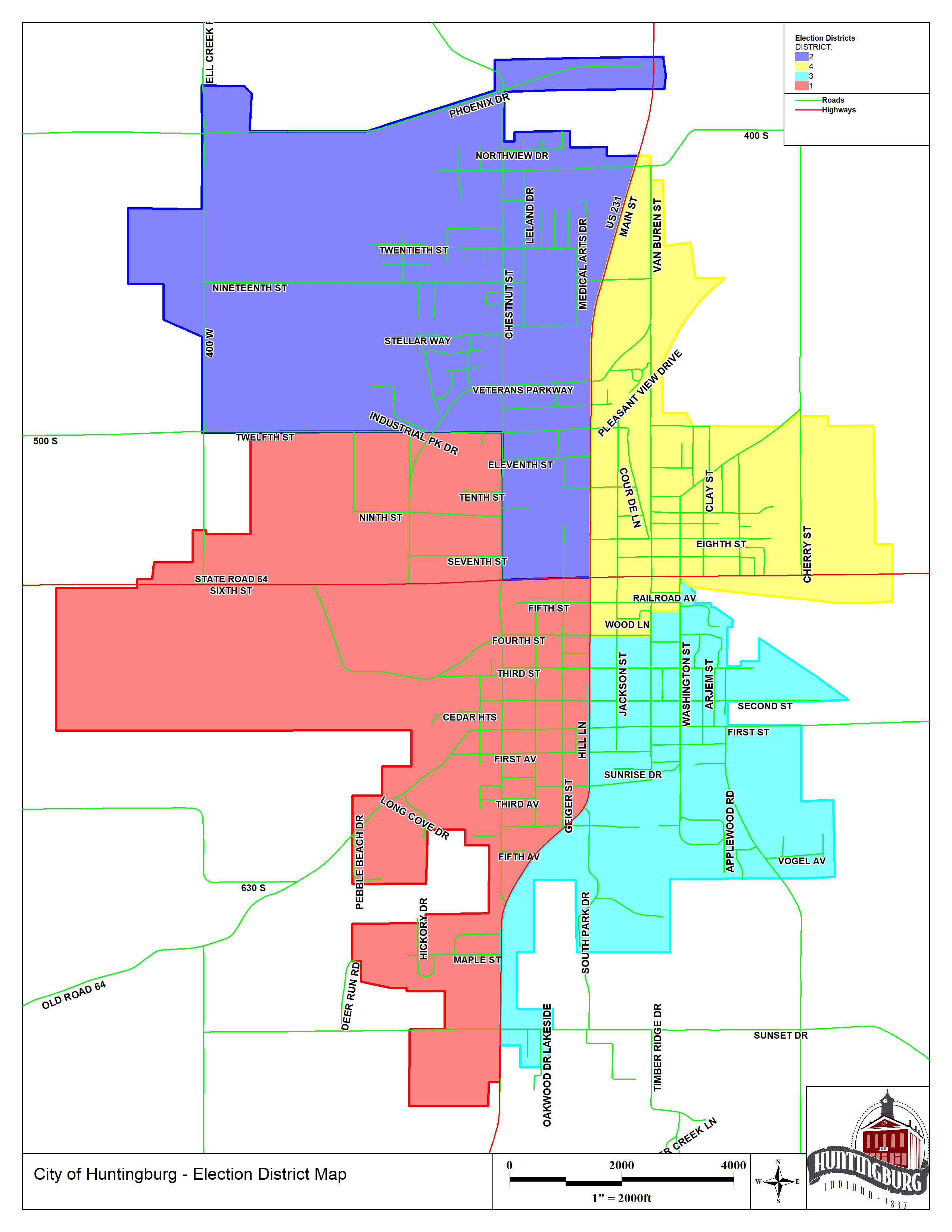
Precinct Boundaries
Precinct One
That part lying within the corporate limits of the city located south of the center-line of 4th Street and west of the center-line of Main Street (U.S. Highway 231); also that part located south of the center-line of West 3rd Street at its intersection with West 4th Street.
Precinct Two
That part lying within the corporate limits of the city located north of the center-line of 4th Street and north of the center-line of West 3rd Street at its intersection with West 4th Street, and west of the center-line of Main Street (U.S. Highway 231); also north of the center-line of Old State Road 231 and west of Van Buren Street; also north of a drainage ditch which crosses VanBuren Street 520 feet South of 19th Street (a census block dividing line) and east of Van Buren Street.
Precinct Three
That part lying within the corporate limits of the city located east of the center-line of Main Street (U. S. Highway 231) and south of the center-line of 4th Street; also east of the center-line of Washington Street and south of the center-line of 6th Street (Highway 64).
Precinct Four
That part lying within the corporate limits of the city located north of the center-line of 4th Street and east of the center-line of Main Street (U.S. Highway 231); excluding that area east of the center-line of Washington Street and south of the center-line of 6th Street (Highway 64); excluding also that area north of the center-line of Old State Road 231 and west of VanBuren Street; excluding also that area lying north of a drainage ditch which crosses Van Buren Street 520 feet South of 19th Street (a census block dividing line) and east of VanBuren Street.
Agendas
- Utility Board/Common Council Agenda - February 10, 2026
- Utility Board/Common Council Agenda - January 27, 2026
- Utility Board/Common Council Agenda - January 13, 2026
- Utility Board/Common Council Agenda - December 23, 2025
- Utility Board/Common Council Agenda - December 9, 2025
- Utility Board/Common Council Agenda - November 25, 2025
Minutes
- Utility Board/Common Council Minutes - January 27, 2026
- Utility Board/Common Council Minutes - January 13, 2026
- Utility Board/Common Council Minutes - December 23, 2025
- Utility Board/Common Council Minutes - December 9, 2025
- Utility Board/Common Council Minutes - November 25, 2025
- Utility Board/Common Council Minutes - November 10, 2025
Meetings
- Common Council/Utility Board Meeting02/24/265:30 pm - 11:59 pm
- Common Council/Utility Board Meeting03/10/265:30 pm - 11:59 pm
- Common Council/Utility Board Meeting03/24/265:30 pm - 11:59 pm
- Common Council/Utility Board Meeting04/14/265:30 pm - 11:59 pm